Special mission aircraft

PRECISION TECHNOLOGY FOR CRITICAL MISSIONS.

Technology-agnostic integrators for airborne and ground platforms. ISR, EO/IR, SIGINT/COMINT, C-UAS — sensor selection, integration, validation, handover.

Technology-Agnostic Integrators of Advanced Technologies for Airborne & Ground Platforms

AIR TEAM Intel leads the way in special solutions and advanced technologies, delivering a full range of custom integrations, upgrades, and innovations. With expertise in groundbreaking systems and exclusive partnerships, we provide tailored, high-performance solutions to meet the most demanding requirements — without vendor lock-in. One programme team from requirements to certified handover.

Special Mission Services

Tailored aviation services for surveillance, emergency response, and infrastructure monitoring, ensuring precision and operational efficiency. From border security to disaster relief, our airborne solutions adapt to special missions, law enforcement, and resource management needs.

Platforms & Data Collection

Utilizing cutting-edge aircraft, helicopters, and UAVs, we provide high-precision data collection, rapid response, and real-time situational awareness. EO/IR, SAR radars, LiDAR, and photogrammetry for superior intelligence gathering, mapping, and environmental analysis.

Mission Systems & Equipment

Secure datalinks, tactical GPS, and mission workstations ensuring seamless coordination, navigation, and real-time data transmission — plus mission-ready lighting, cargo solutions, UAV payload integration, and counter-UAV technologies designed for operational success.

Mission Domains

Surveillance and security, emergency response, aerial surveying, and ISR mission systems — airborne solutions that adapt to the operational realities of government, defence, and civil operators.

Surveillance and security

Surveillance & Security

Border control, maritime patrol, law enforcement, force protection, and airborne drone detection.

Emergency services

Emergency Services

Search & rescue, HEMS, medevac, firefighting, and disaster relief — rapid response with real-time situational awareness.

Surveying and mapping

Aerial Surveying & Mapping

Photogrammetry, LiDAR scanning, hyperspectral imaging, and corridor mapping for infrastructure and environmental programmes.

ISR mission systems

ISR Mission Systems

Mission control units, ISR pods, datalinks, EO/IR (incl. WESCAM MX-series class systems), SIGINT/COMINT, and platform integration.

Surveillance & Security

Airborne surveillance systems combine signal detection and interception, direction finding with geolocation, wide frequency coverage across VHF, UHF, HF, and satellite channels, and mission workstation integration for real-time analysis — a layered surveillance network capable of operating across varied terrains and conditions.

Border Control

The Role of Advanced Technologies in Border Surveillance

Border surveillance is a vital pillar of national security, focused on detecting and preventing unauthorized activities such as illegal crossings, smuggling, and potential threats. By combining electro-optical sensors, portable radars, UAVs, and signal intelligence tools, security forces establish a layered surveillance network operating across varied terrains and conditions.

Maritime Patrol

Securing Waters Through Advanced Surveillance

Systematic monitoring of maritime areas to identify and manage human activities — essential for national security, law enforcement, economic interests, and environmental protection. Navies monitor and identify vessels and submarines, law enforcement intercepts smuggling and unauthorized immigration, and patrols safeguard fishing zones and shipping lanes while supporting SAR for vessels in distress.

Law Enforcement

Enhancing Public Safety from Above

Airborne Law Enforcement (ALE) units provide rapid response, surveillance, and mission support: monitoring criminal activity, large gatherings, and traffic in real time; locating missing persons with thermal imaging; supporting EMS evacuations, wildfire observation, and border patrols against illegal crossings and smuggling.

Force Protection

Aerial Surveillance for Threat Detection

Force protection relies on aerial surveillance to safeguard military personnel, critical assets, and operational zones. From military bases and forward operating locations to convoy security and border defence, airborne solutions monitor hostile activity, detect unauthorized intrusions, and provide early warning — supporting tactical decision-making in combat zones, peacekeeping missions, and security operations.

Drone Detection

Securing Airspace with Advanced Surveillance

Unauthorized and hostile UAVs pose significant threats to critical infrastructure, public safety, and military operations. Airborne drone detection systems use advanced sensors, radar, and signal intelligence to detect, classify, track, and mitigate rogue drones in real time — preventing espionage, smuggling, and airspace intrusions before they escalate.

Infrastructure Monitoring

Aerial Intelligence for Sustainable Management

High-resolution sensors and autonomous systems enable detailed assessment of landscapes, vegetation health, pollution levels, and the structural integrity of powerlines, pipelines, and urban infrastructure — unmatched accuracy and efficiency across vast and hard-to-reach areas for public safety, government, and industrial sectors.

Emergency Services

Rapid response through advanced technology — from search & rescue and airborne medical services to firefighting, disaster relief, and environmental protection.

Search & Rescue (SAR)

Integrating UAVs, AI, and real-time data processing lets SAR teams survey large areas quickly, identify potential victim locations, and deploy resources efficiently. Satellite systems ensure instant detection of distress signals, while mobile-phone geolocation systems turn any handset into an emergency beacon — even without network coverage.

HEMS

Helicopter Emergency Medical Services deliver rapid medical assistance and patient transport in time-critical situations. Integrated aviation and medical technologies allow HEMS providers to deliver hospital-level care both at the scene and during transport, closing the gap between emergency response and hospital treatment.

Medevac

Fast, life-saving air transport for injured or critically ill patients from remote locations, disaster zones, and combat environments. Airborne medevac requires real-time communication, precision navigation, and specialized onboard medical equipment to stabilize patients in transit — including military casualty evacuation (CASEVAC).

Firefighting

Specialized firefighting aircraft, UAVs, and sensor systems provide real-time aerial surveillance, fire suppression, and strategic coordination. EO/IR thermal imaging detects hotspots while helicopters and fixed-wing aircraft deploy water, foam, or retardants to control wildfires in challenging terrain.

Disaster Relief

UAVs, AI, and data analytics allow responders to quickly assess affected areas, optimize resource distribution, and enhance coordination. GIS mapping aids planning while real-time communication ensures seamless collaboration among response teams and affected populations.

Oil Spill Detection

A multi-layered detection approach combines SAR radar for wide-area surveillance, UAVs for localized inspections, and hyperspectral imaging for detailed spill analysis — enabling emergency services to identify, track, and contain spills efficiently, even in challenging conditions.

Pipeline & Powerline Monitoring

Helicopters and fixed-wing aircraft cover vast areas quickly while UAVs perform close-up inspections. LiDAR and infrared sensors detect structural weaknesses, vegetation encroachment, and thermal anomalies before failures escalate — ensuring continuous service reliability and public safety.

Wildlife & Environmental Monitoring

Fixed-wing aircraft conduct large-scale patrols while UAVs with EO/IR sensors and laser scanning provide detailed, localized monitoring. SATCOM ensures real-time data transfer for conservation missions, anti-poaching support, and emergency response in environmentally sensitive areas.

Aerial Surveying & Mapping

High-precision geospatial data acquisition from fixed-wing aircraft, helicopters, and UAV platforms — for infrastructure development, environmental assessment, and asset management.

Photogrammetry

High-resolution imaging systems capture precise spatial data processed into accurate 2D maps and 3D models. Fixed-wing aircraft efficiently cover large areas for high-altitude mapping, while helicopters excel at high-resolution imagery at lower altitudes. Combined with LiDAR, photogrammetry enables detailed terrain analysis and infrastructure assessment.

Laser Scanning (LiDAR)

Airborne LiDAR emits laser pulses to create detailed 3D point clouds — Digital Elevation Models and Digital Surface Models for terrain mapping, urban planning, flood modelling, forestry and vegetation monitoring, and disaster response. Helicopter-mounted LiDAR delivers high-resolution, low-altitude scans; fixed-wing platforms cover large areas fast.

Hyperspectral Imaging

Advanced sensors capture detailed spectral data across a wide range of wavelengths — essential for mineral exploration, vegetation analysis, and environmental monitoring. Integrated with LiDAR and multispectral imaging and refined by machine learning, hyperspectral data delivers high-resolution insight into surface composition and ecological conditions.

Corridor Mapping

Capturing high-precision geospatial data along roads, railways, pipelines, and powerlines. Helicopters equipped with LiDAR provide detailed low-altitude scans, fixed-wing aircraft cover extensive corridors, and multispectral and hyperspectral sensors detect environmental risks along critical infrastructure.

Mission-Driven Engineering

We specialize in the integration of advanced Intelligence, Surveillance, and Reconnaissance (ISR) technologies across civil and military aviation platforms. From light aircraft to UAVs and rotorcraft, our solutions are tailored to operational realities and mission-specific demands — with certification support through AIR TEAM Engineering DOA, NATO AQAP 2110 and Military Part 145 approvals, and local validations in Ukraine, Serbia, Israel, and Taiwan.

Turnkey ISR Solutions

Complete development, certification, and integration of ISR suites — we deliver fully mission-configured aircraft, not component kits.

Modular Mission Pods (IP-POD)

Rapidly deployable ISR pods equipped with EO/IR gimbals, SIGINT sensors, and MANET/SATCOM datalinks.

Custom Operator Workstations

Lightweight, ergonomic consoles for one or two operators with plug-and-play Mission Control Unit.

Real-Time Data Delivery

LOS and BLOS communication systems with secure data relay to C2 centers.

Rapid Prototyping & In-House Manufacturing

CNC machining, 3D printing, clean-room electronics lab, and finishing/refurbishment facilities.

Facility Capabilities

Avionics laboratory — FAA/EASA Part 145 certified, Honeywell, Collins, and Garmin authorized — with environmental test chambers and NVG modification capability.

ISR Platform Integration

We deliver fully mission-configured aircraft, integrating:

  • Sensors: EO/IR, SAR radar, SIGINT, AIS receivers, laser scanners, sonobuoys
  • Communications: LOS, SATCOM, tactical radios, 3G/4G/5G datalinks
  • Mission systems: custom Mission Control Units, secure networks, onboard data recorders
  • Platforms: light aircraft, special-mission aircraft, rotorcraft, and UAVs

Sensor Technologies

Sensor technologies are at the core of modern airborne intelligence — real-time surveillance and data acquisition for military, security, emergency response, and industrial applications, specified without vendor lock-in and validated to programme requirements.

EO/IR Sensors

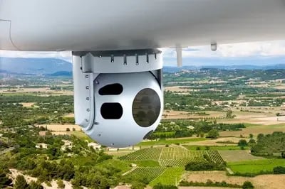
Electro-optical/infrared systems combine EO imaging for daylight and IR for night or poor visibility — real-time video streaming, gyro-stabilized platforms, long-range detection, and multi-spectral imaging. Short-Wave Infrared (SWIR, 0.9–1.7 µm) delivers clear imagery through haze, smoke, and fog, resisting thermal crossover and using natural light sources like moonlight for low-light imaging.

Representative systems we integrate: L3Harris WESCAM MX-10 and MX-15 turrets, FLIR Star SAFIRE 380-HD/HDc, Thales Euroflir 410, Hensoldt Argos II (ITAR-free 16" class), and the compact TrakkaCam TC-300.

SAR Radars

Synthetic Aperture Radar delivers high-resolution radar imagery in all weather and lighting conditions — change detection, wide-area coverage, long-distance imaging, and Ground Moving Target Indication (GMTI) for tracking stationary and moving targets in real time. Critical for border and maritime patrol, infrastructure monitoring, SAR, and emergency mapping.

Representative systems: IMSAR NSP-3/5/7 multi-mode Ku-band radars, Thales I-Master, Hensoldt PrecISR 1000 AESA, and Leonardo Seaspray/Osprey AESA families.

Laser Scanners (LiDAR)

Airborne LiDAR generates detailed point-cloud data for accurate 3D models of landscapes, infrastructure, and natural resources — surveying and corridor mapping, topographic and terrain modelling, forestry and vegetation monitoring, disaster assessment, and mining and resource exploration, including bathymetric variants for coastal and shallow-water mapping.

SIGINT / COMINT

Signals and communications intelligence sensors enable real-time interception, analysis, and geolocation of signals from communication systems, radar, and electronic devices. Deployed on aircraft and UAVs, they detect adversary communications and radar to locate forces across wide areas — supporting defence, border patrol, and counter-terrorism operations.

Representative systems: Smith Myers ARTEMIS mobile-phone detection and location, Horizon BlackFish tri-band satellite-phone SIGINT, and CENTUM Lifeseeker airborne phone geolocation for SAR.

Direction Finders

DF systems detect and track the bearing of RF emitters — precise navigation support, signal tracking, and emitter geolocation across 30 MHz to 3 GHz, from AM/FM voice and pulsed emergency locator signals to encrypted tactical communications.

Representative systems: Collins DF-500 (COSPAS-SARSAT 406 MHz, ARGOS, AIS, DSC), Chelton DF-935 tactical direction finder, and Rhotheta RT-600 for SAR and law enforcement.

Military GPS & Inertial Systems

Military GPS receivers using encrypted P(Y)-code or M-Code signals, decoded via SAASM or MGUE modules, ensure high-integrity navigation in contested electronic-warfare environments — and serve as the foundational timing source for C4ISR systems and secure networks.

Representative systems: L3Harris M-Code receivers, BAE Systems DIGAR anti-jamming receiver, Honeywell H-764 EGI, Northrop Grumman LN-100G/LN-251 INS, GSS GeoPro INS, and Honeywell HG1930 IMU.

Advanced Avionics

Avionics systems are the technological backbone of special-mission aviation — precision navigation, real-time threat detection, and mission-critical decision-making for manned and unmanned aircraft, including GPS-denied environments, low-visibility conditions, and contested airspace.

IFF Systems

Identification Friend or Foe transponders and interrogators operating across Modes 1, 2, 3/A, C and encrypted Modes 4 and 5 — the NATO standard for secure identification with cryptographic key management. Representative systems: Hensoldt LTR 400 Mode 5 transponder, Thales TSA 3520 and Leonardo SIT434CI interrogators.

Weather Radars

Modern airborne weather radars with Doppler processing and multi-tilt volumetric scanning detect precipitation, turbulence, and wind shear with high accuracy. Representative systems: Honeywell IntuVue RDR-7000 and RDR-4000M (military 3D radar with high-resolution ground mapping), Garmin GSX 70, and Collins RTA-4100 MultiScan.

TACAN

Tactical Air Navigation — line-of-sight UHF navigation (962–1213 MHz) providing robust range and bearing data for military aviation, integrated with INS/FMS via ARINC 429 and MIL-STD-1553B. Representative systems: Collins AN/ARN-153, L3Harris IN602 indicator, BendixKing KTU-709 receiver.

NVG Integration

Night Vision Goggles demand full Night Vision Imaging System (NVIS) compliance per MIL-STD-3009 — instrument backlighting, multi-function displays, HUDs, and external lighting modified or certified to emit NVG-compatible wavelengths that prevent glare or washout. We perform complete cockpit NVG compatibility modifications.

Digital Moving Maps

DMMs display real-time aircraft position over layered geo-referenced maps — raster and vector formats (GeoTIFF, ECW, JPEG2000, SHP, VMAP) with GIS overlays. On ISR and SAR platforms they integrate with EO/IR and radar to show sensor footprints and cue cameras directly from the map interface.

Military Collision Avoidance (MILACAS-XR)

Extended-range military TCAS with hybrid surveillance — active interrogation plus passive ADS-B — doubling surveillance range to 100 NM. Interoperable with military IFF, approved for platforms including C-130J, V-22, C-27J, and CN-295.

AeroIntel ISR Suite — Mission Systems

Mission workstations are the central hub for data processing, surveillance, and tactical decision-making — integrating sensor feeds, video management, mapping, and communications for real-time situational awareness in dynamic, high-risk environments.

Mission Control Unit (MCU)

Our MCU features a fully integrated touchscreen interface with a customized display and Line Replaceable Unit (LRU) configuration. Designed with a plug-and-play philosophy, its tool-free quick mount and demount capability enables effortless installation and removal across workstation environments.

  • LOS operations: data transmitted through ground antennas — stable, high-speed connection up to 150 km
  • BLOS operations: continuous data links over 3G/4G/5G cellular networks, even in remote areas
  • AIS integration: vessel positions overlaid onto EO/IR or radar feeds for target identification and tracking
  • Onboard data recorder: full-mission storage with removable SD cards for post-mission debriefing and analysis

Mission Displays & Operator Workstations

Ergonomic, lightweight consoles with high-resolution displays and rugged construction for extended missions — customizable layouts and modular components uniting EO/IR, radar, and communications into a cohesive workspace.

  • High-resolution, anti-glare screens for all lighting conditions
  • Real-time display of sensor feeds, maps, system status, and communications
  • Customizable layouts matching mission-specific workflows
  • Touchscreen control with fast switching between sensor views and mission overlays
  • Reliable performance under vibration, temperature, and airborne operational stress

Video Recorders & Switch Matrix

High-resolution, multi-channel mission video recorders capture, store, and manage feeds from onboard sensors and cameras for real-time analysis and post-mission review. A video switch matrix dynamically routes multiple video streams from sensors, cameras, and mission systems — consolidating feeds for comprehensive mission coverage and battlefield awareness.

Remote Control & Monitoring Workstations

Centralized ground platforms for managing unmanned aerial systems during mission-critical operations — UAV control, sensor-feed monitoring, and real-time data analysis with tactical overlays for surveillance, SAR, military operations, and environmental monitoring.

Secure, Real-Time Connectivity for Mission Success

From high-speed data links to satellite-based global connectivity — secure, interference-resistant communication for airborne, ground, and remote operations, whether in high-risk zones, disaster-stricken areas, or remote surveillance missions.

Mesh Datalinks

Dynamic, self-healing networks connecting multiple nodes — aircraft, UAVs, ground stations — without a central hub. Encrypted, real-time video and data sharing for tactical ISR, SAR, disaster response, and border and coastal surveillance across distributed air and ground assets.

Point-to-Point Datalinks

Reliable, secure connections between two endpoints — aircraft, ground stations, or UAS. Real-time transfer of EO/IR video, telemetry, and sensor data to command centers with anti-jamming, low-latency performance for ISR and SAR streaming.

SATCOM (BLOS)

Beyond-Line-of-Sight satellite communications for long-range, real-time voice, data, and video — global reach even in contested environments. Representative systems: SkyTrac SDL-350 (Iridium Certus, up to 704 Kbps), Cobham AVIATOR 700D, Thales MissionLINK, and Iridium Certus terminals with 100% global coverage including polar regions.

Airborne 5G LTE

High-speed, low-latency broadband connectivity turning aircraft and UAS into mobile communication hubs — restoring networks in disaster response, streaming high-bandwidth video for SAR, and extending temporary 5G/LTE coverage to regions with limited connectivity.

Unmanned Systems & Counter-UAV

Autonomous, high-precision capabilities for surveillance, reconnaissance, mapping, and security — AI-driven navigation, real-time data transmission, and seamless integration with manned assets.

Aerial Drone Platforms

Unmanned platforms for high-precision data collection and real-time situational awareness — border monitoring, thermal-imaging SAR, disaster assessment, environmental tracking, and close-proximity infrastructure inspection in hard-to-reach areas.

Payload Integration

Enabling drones and UAVs to carry EO/IR systems, SAR radar, and laser scanners — seamless integration so unmanned systems adapt to mission-specific requirements while maintaining performance and reliability across surveillance, mapping, SAR, and inspection missions.

Autonomous Navigation

AI, machine learning, and sensor fusion for precise navigation, obstacle avoidance, and mission execution with minimal human intervention — long-endurance monitoring of borders and infrastructure, and navigation of challenging terrain in SAR and disaster response.

Counter-UAV Solutions

Detect, track, and neutralize unauthorized or hostile UAVs — protecting critical infrastructure, military assets, borders, public events, and emergency operations. Comprehensive airspace security in both urban and remote environments, from detection and classification through mitigation.

Specialized Mission Equipment

From life-saving medical gear to firefighting tools and tactical enhancements — equipment solutions that ensure aircraft and crews are prepared for any mission environment, integrated and certified as part of the platform.

Equipment & Accessories

  • Medical equipment for medevac, HEMS, and disaster response — in-flight stabilization and advanced life support
  • Firefighting equipment — precise delivery of water, retardants, and foam from helicopters and fixed-wing aircraft
  • Oxygen systems for high-altitude and emergency operations
  • Hardpoints securing external sensors, payloads, and fuel tanks
  • Floats & rafts for water operations and overwater safety
  • Bubble windows for enhanced observer visibility in SAR and surveillance
  • Cable cutters protecting low-altitude rotary-wing operations
  • Fast Rope Insertion Extraction Systems (FRIES) for rapid personnel deployment

Lighting & Visual Solutions

  • Search lights — high-intensity, gyro-stabilized illumination with visible and infrared modes for SAR, law enforcement, and border surveillance
  • Steerable & landing lights — adjustable, high-intensity illumination for night operations, including infrared modes for covert missions
  • Mirror lights for external load operations and night hoisting
  • Emergency egress lighting — illuminated evacuation pathways meeting aviation safety standards, with low-visibility options for tactical operations

Cargo & Lift Solutions

  • Hoists — precision lifting of survivors, personnel, and equipment in SAR, military, and maritime operations
  • External cargo systems — sling and hook transport of heavy loads to remote or inaccessible areas
  • Cargo mirrors providing pilots a clear view of external loads for safe, precise handling
  • Line inspection systems — high-pressure spray, corona cameras, and thermal imaging for powerline and pipeline maintenance

Integrated ISR Capability — Our Process

Sensor selection, structural integration, wiring, ground testing, flight validation, and operator training — under one programme manager, from first requirement to certified handover.

01 — Requirements

Mission Analysis & Sensor Selection

Technology-agnostic specification against operational realities and mission-specific demands — sensors, communications, and mission systems selected on merit, not vendor preference.

02 — Integration

Structural Integration & Wiring

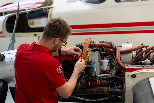
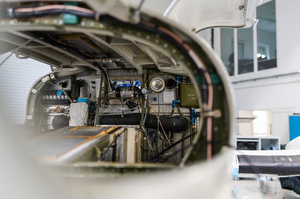
Hardpoints, pods, turret mounts, operator consoles, and full electrical installation — engineered, manufactured, and installed in-house with certification support through AIR TEAM Engineering DOA.

03 — Validation

Testing, Flight Validation & Handover

Ground testing, flight validation, and operator training — the aircraft is handed over mission-configured, documented, and audit-ready.

Reference Programmes

Selected special-mission integrations — further details available under NDA.

ISR Mission System

GOSHAWK ISR Mission System

Platform: TECNAM P2012 Special Mission Aircraft · Location: Taitung Airport (RCFN) · Certification: EASA / FAA

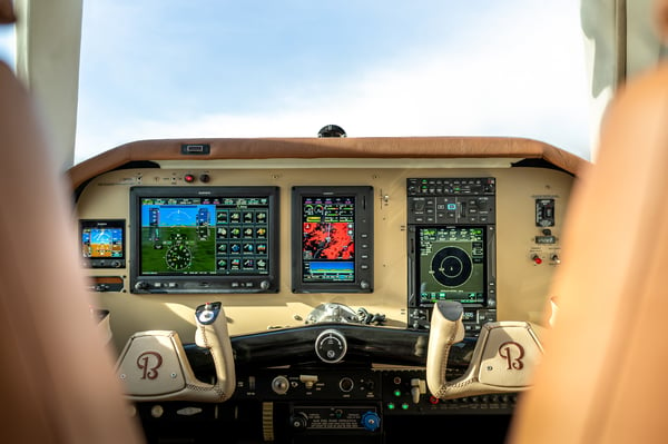
A versatile ISR solution integrating cutting-edge technology, multi-domain connectivity, and ergonomic mission control into a compact airborne platform. The TECNAM P2012, modified into a Special Mission Platform, merges endurance, efficiency, and payload flexibility — IFR-certified with a Garmin G1000 cockpit, ceilings up to 19,500 ft, and 5–7 hour missions supported by enhanced onboard power systems.

  • EO/IR: FLIR Star SAFIRE 380-HD — full-HD multi-sensor with digital image blending and precision targeting
  • Radar: IMSAR NSP-7 — SAR, GMTI, MMTI, all-weather day/night operations
  • AIS receiver integrated with SAR/EO for vessel tracking
  • SIGINT phone tracker, laser scanner, sonobuoy support, tactical radios
  • 3G/4G/5G networks for extended BLOS missions
  • Ergonomic, lightweight carbon-fiber operator workstation with quick mount/demount design
  • Plug-and-play Mission Control Unit with touchscreen and built-in recording
R&D Programme

Multifunctional IP ISR Pod

Partner: Brno University of Technology — Institute of Aerospace Engineering

A versatile aircraft pod supporting ISR operations over IP-based communication systems — robust remote sensing, high-speed secure data transmission, and exceptional operational flexibility for government agencies, security forces, and special-mission operations, at home and abroad.

  • Quick adaptability to various general-aviation aircraft; lightweight design meeting ULL weight limits
  • Data transmission beyond 100 km using relay aircraft or the ViMA drone acting as a 100 m aerial mast
  • Automatic cloud connectivity — remote access to video, voice, and data
  • Phase I (2021–2022): prototype build, ground and initial flight tests
  • Phase II (2022–2023): EASA approval obtained; data/voice/video transmission validated at distances over 100 km, including a verified 61.5 km link via drone relay positioned 34.8 km away

Authorized integrator for leading sensor and avionics OEMs

L3Harris WESCAM, Hensoldt, Garmin, BendixKing, Thales, Honeywell — installed and validated by factory-trained engineers.

Audit-Ready Delivery

NATO AQAP 2110 · č. 33/2-2024 · valid to 30 Apr 2027 Military Part 145 · CZE.145.1004 EASA Part 21J DOA · AIR TEAM Engineering · EASA.21J.849 ISO 9001:2015 Military Trade License Local validations: Ukraine · Serbia · Israel · Taiwan

Full certification register →

Contact Intel

Defence and government programmes require discretion. Submit your enquiry via our secure contact channel — no public e-mail address.

With deep expertise in special-mission technologies and solutions, our business development team helps you explore advanced systems and find the best-fit solution for your mission-critical operations — led by Mateusz Blicharz, Director of Business Development.

Request Confidential Briefing

Programme enquiries are routed to our defence business development team. Response within two business days.